


Property details last updated: 17 Jun, 2026
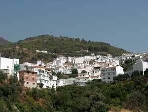
Canillas de Aceituno is in the north of the Axarquia region and is situated on the slopes of the Sierra Tejeda at an altitude of 645 metres. The highest mountain of this sierra is the Maroma peak (2.065 m.) The natural spring from the mountain attracts people from far away in the belief that the waters will prevent illness. Nearby is the spectacular canyon of the River Almachares where picnic and barbeque areas are provided. The nearby Cave of La Fajara and the Rahíges Nature Reserve are also worth visiting. Canillas de Aceituno is approximately an hour's drive from Malaga airport and 20 minutes drive from the coast at Torre del Mar and has a population of 2,800. The town derived its name from the 8th century Moorish name of Azeytuni. Despite the similarity to the Spanish word for olive (spelt acietuno), 'aceituno' is the Arab word for a coloured fabric made with silk.
A new public outdoor swimming pool with a bar, children's pool and playground has been opened on the outskirts of the village. As with the whole village, this is surrounded by superb mountain, lake and sea views. Another recent improvement has been the construction of a by-pass around the village which means that there is far less through traffic than previously.